(日本語の要約は最後にあります)
Nagasaki is located on the western edge of Kyushu, facing the East China Sea. It is often described as one of Japan’s most open regions to the outside world. However, when we look closely at its geography, we can see something more interesting. Nagasaki is not simply open. In many ways, it is shaped by narrow passages that connect very different worlds.
One symbolic place for understanding this is Saikai Bridge. This bridge crosses a narrow channel called Hario Seto. The water there moves very fast, and strong whirlpools appear when the tide changes. The view is powerful and dramatic. The sea seems to twist and breathe under the bridge, and many people stop there just to watch the flow of the water.
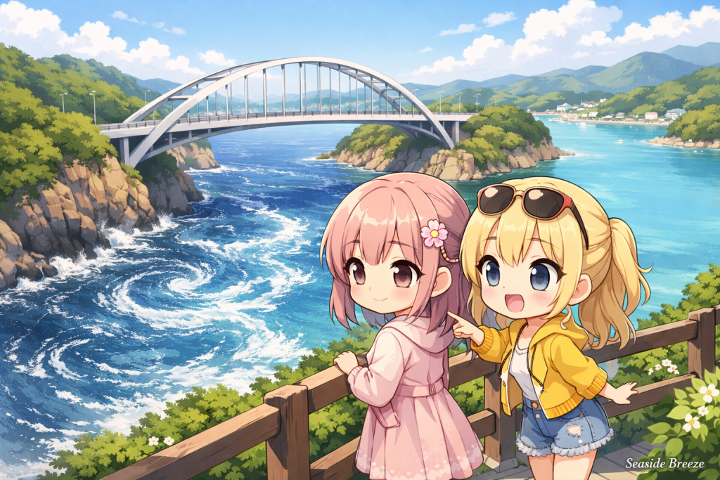
What makes this place especially important is its relationship with Omura Bay. Omura Bay is a quiet inland bay with gentle waves and a peaceful atmosphere. Compared with the outer sea, it feels calm and almost protected. But between the bay and the open sea, there is this narrow passage where the currents become wild. It is like a gate between two different kinds of water.
This contrast tells us something important about Nagasaki itself. The region has long been connected to foreign countries, trade, and new ideas. At the same time, those connections often passed through limited places rather than through a wide and simple opening. In that sense, Nagasaki was not a land that was open everywhere. It was a place where the outside world entered through selected points.
That image fits Japanese history very well. During the Edo period, Nagasaki became famous as a contact point with other countries. Even when Japan limited most foreign relations, Nagasaki still kept a connection with the outside world. This role was possible not only because of politics, but also because of geography. The land and sea of Nagasaki naturally create boundaries, channels, and controlled entrances.
Saikai Bridge and Hario Seto are small examples of this larger idea. On one side, there is the calm inner bay. On the other side, there is the outer sea leading toward distant places. Between them, the current becomes narrow, fast, and intense. This is why the place feels so memorable. It is not only beautiful. It expresses the character of Nagasaki in a very physical way.
Many parts of Japan are known for mountains, plains, or large rivers. Nagasaki, by contrast, is often understood through coastlines, islands, bays, and straits. Its geography is full of edges and transitions. Water is never just background there. It shapes daily life, transportation, local identity, and even historical meaning.

When people think of Nagasaki, they often imagine foreign culture, old ports, churches, or famous historical sites. Those are all important. But before talking about those cultural layers, it is useful to begin with the land and sea themselves. The meeting point between Omura Bay and the outer sea shows that Nagasaki has always been a place of connection, but also of distance, selection, and contrast.
That is one reason why Nagasaki feels different from many other prefectures in Japan. It does not simply face the world. It filters the world through narrow gateways. Saikai Bridge is not just a bridge with a good view. It is a place where we can quietly understand the deeper geography of Nagasaki.
(今回のお話を要約するとこのような内容になります)
長崎県は海外に開かれた土地として知られていますが、その特徴は単純な「開放性」ではありません
西海橋のかかる針尾瀬戸は、静かな大村湾と外海を結ぶ細い海峡で、渦潮が生まれるほど潮の流れが激しい場所です
この内海と外海の対比は、長崎が限られた入口を通じて外の世界とつながってきた土地であることを象徴しています
地形そのものが、長崎の歴史や個性をよく表しています


コメント